 Access to ski resort
Access map/travel map
You can move, enlarge, reduce as well as change the view of the map.
Access to ski resort Town/village close to ski resort
 Traffic Junction
 Airport
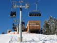
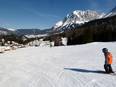
Travel route Spieljoch – Fügen
All information is supplied without guarantee
The maps are provided by Google with the following information: „These directions are for planning purposes only. You may find that construction projects, traffic, weather, or other events may cause conditions to differ from the map results, and you should plan your route accordingly. You must obey all signs or notices regarding your route.“
Towns/villages at the ski resort (distance from town center):
Fügen (1.1 km), Hart im Zillertal (4 km), Uderns (4 km), Schlitters Towns/villages at the ski resort
Fügen (1.1 km), Hart im Zillertal (4 km), Uderns (4 km), Schlitters Towns/villages at the ski resort
Feedback for the Skiresort.info Team? Please use this form