Ski resorts Italy
Route planner Passo dello Stelvio (Stelvio Pass)
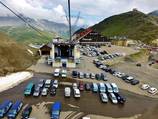
Access Passo dello Stelvio (Stelvio Pass) & on-site parking
The Stelvio Pass road connects Bormio in Veltlin (Lombardy region) with Prad in the Vinschgau Valley (South Tyrol). It is the second highest paved road in the Alps. The ski resort begins at the top of the pass. The drive from Vinschgau/South Tyrol to the Stelvio Pass is rather difficult. The road is easy up until the beginning of the pass road on the Stelvio Pass. You must then drive through 48 curves up to an elevation of 2760 m. Some parts of the road are single lane and snow chains are recommended. During the weekends, there are often long streams of cars due to the pass road's spectacular reputation. The roads from Bormio and Switzerland lead up steeply from the west. Winter Closure
The Stelvio Pass road is closed during the winter. Therefore, the ski resort is also closed.
Access via
- Brenner Autobahn, Exit Bolzano Süd (South)
100 km approx. 84 min » - A12 Inntal Autobahn, Exit Reschen
105 km approx. 93 min » - A52 Tangenziale Nord di Milano, Exit Monza - Villa Reale
206 km approx. 172 min » - Autobahn A13 St. Margrethen-Bellinzona, Exit Landquart
126 km approx. 134 min »
Mobility on-site
- No ski buses
- Scheduled buses
- There is a scheduled bus operated by Automobilistica Perego that travels twice a week from Bormio and from Trafoi to the ski resort.
Access via Brenner Autobahn, Exit Bolzano Süd (South)
100 km Distance - approx. 84 Minutes driving time
Destination - Passo Stelvio, 23032 Passo Stelvio, Italy
- Ideal entry for day visitors
- View on Google Maps
- usually enough available, tarmac car park
- free of charge
- Highway, Main street, Mountain pass road, partially developed, with significant incline
- Snow chains required very often by snowfall
- Road closure due to avalanches very often possible
Access via A12 Inntal Autobahn, Exit Reschen
105 km Distance - approx. 93 Minutes driving time
Destination - Passo Stelvio, 23032 Passo Stelvio, Italy
- Ideal entry for day visitors
- View on Google Maps
- usually enough available, tarmac car park
- free of charge
- Highway, Main street, Mountain pass road, partially developed, with significant incline
- Snow chains required very often by snowfall
- Road closure due to avalanches very often possible
Access via A52 Tangenziale Nord di Milano, Exit Monza - Villa Reale
206 km Distance - approx. 172 Minutes driving time
Destination - Passo Stelvio, 23032 Passo Stelvio, Italy
- Ideal entry for day visitors
- View on Google Maps
- usually enough available, tarmac car park
- free of charge
- Main street, Side road, Mountain pass road, partially developed, with significant incline
- Snow chains required very often by snowfall
- Road closure due to avalanches very often possible
Access via Autobahn A13 St. Margrethen-Bellinzona, Exit Landquart
126 km Distance - approx. 134 Minutes driving time
Destination - Passo Stelvio, 23032 Passo Stelvio, Italy
- Ideal entry for day visitors
- View on Google Maps
- usually enough available, tarmac car park
- free of charge
- Main street, Side road, Mountain road, Mountain pass road, partially developed, with significant incline
- Snow chains required very often by snowfall
- Road closure due to avalanches very often possible
 Access to ski resort
  Town/village close to ski resort
  Traffic Junction
 All information is supplied without guarantee
The maps are provided by Google with the following information: „These directions are for planning purposes only. You may find that construction projects, traffic, weather, or other events may cause conditions to differ from the map results, and you should plan your route accordingly. You must obey all signs or notices regarding your route.“
Feedback for the Skiresort.info Team? Please use this form »
Book this ski resort
Tips for the ski holiday


