Evaluated by Skiresort.info, the world's largest test portal for ski resorts.
The evaluation is done as follows
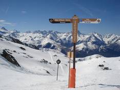
Orientation (Trail map, information boards, sign-postings) and safety in the ski resort Alpe d'Huez
The printed trail maps of Alpe d'Huez are clearly laid out and sufficiently large. On the back of the map, the operating hours of all major lifts are listed in a table. The map also includes information on safety precautions and emergency numbers. Unfortunately, it is not clear exactly what type of lifts are shown. In addition to the fold-out maps, there is an informative app available for smartphone users. This app is free for iPhone and Android. Information about the opening status of lifts and slopes, as well as emergency numbers and many other useful details, is presented in a particularly user-friendly way.
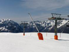
There is a uniform signage system throughout the entire area. Information about slope names, levels of difficulty, and destinations or lifts is clearly presented and easy to understand. At intersections, these signposts also indicate the open status of the branching runs. In addition to the signposts, large overview boards are available at many lift stations, which also display the open status of lifts and slopes. At the valley stations of the larger lifts, maps are provided. These show in detail the runs accessible from that lift. Electronic displays at many of the larger lifts inform visitors about the occupancy of the different sectors of the area. This allows guests to avoid particularly busy areas and long lift lines.


Feedback for the Skiresort.info Team? Please use this form