Evaluated by Skiresort.info, the world's largest test portal for ski resorts.
The evaluation is done as follows
Orientation (Trail map, information boards, sign-postings) and safety in the ski resort Bad Gastein/Bad Hofgastein – Schlossalm/Angertal/Stubnerkogel
Trail map and overview maps
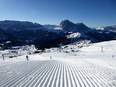
The slope map provides an excellent overview of the Skigastein ski areas. All lifts and slopes are marked. Additionally, the highlights of the ski area are shown. Details about the ski huts could be added.
Information boards and sign-postings on the slopes
Panoramic information boards with up-to-date information can be found at all mountain and valley stations, as well as at key locations throughout the ski area. The multimedia panoramic boards and monitors are very modern. Signposting is generally very good. The important destinations Bad Gastein, Bad Hofgastein, and the Skizentrum Angertal are clearly indicated.
Trail map

Ski Gastein Season 2025/2026
Top Orientation


17 strengths of this ski resort


Feedback for the Skiresort.info Team? Please use this form

Select specific criteria
Top evaluation criteria
Further evaluation criteria
Orientation (trail map, information boards, sign-postings)
Evaluation criteria for special interests
Feedback for the Skiresort.info Team? Please use this form
Test Reports
Tips for the ski holiday